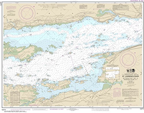
NOAA Chart 14771 Butternut Bay, Ont., to Ironsides l., N.Y.: 28.52" X 36.27" Paper Chart By MapHouse
Key features
- •NOAA Chart 14771 is printed on demand by Certified NOAA chart agent: MapHouse LLC.
- •Printed on demand using the most up to date NOAA dataa and latest Notice to Mariners (NTMs) applied at time of print.
- •Meets United States Coast Guard carriage requirements.
- •Pre-production finishing for display quality. Ships flat with no folds: Rolled in a tube.
- •Scale: 1:15000
BrandMapHouse
CategoryCharts & Maps
NOAA Chart 14771 Butternut Bay, Ont., to Ironsides l., N.Y.: 28.52" X 36.27" Paper Chart By MapHouse
List Price: $36.65$32.99DEALYou Save: $3.66 (10%)
Free shippingFree Returns – 30 daysFree Order CancellationSecure Payment2–3 Days DeliveryGet It June 24, 2026In Stock (1)No marketing spamNo account requiredFulfilment by FedEx / Amazon / UPS / ShipwirePayPal / Card Buyer Protection
Related products


C-MAP Reveal - US Lakes North Central, Map Card for Marine GPS chartplotters
List: $260.45$234.41DEAL